
Laboratories
ProfessorNAKAMURA Shozo
Field of Specialty
Steel Structure / Maintenance Engineering
Research Topics


- Maintenance of Existing Structures
- Degradation curve of structural members, remaining load bearing capacity and life, correlation between atmospheric corrosion environment as well as corrosion speed, and durability of corrosion protection methods have been studied through field survey, remote monitoring, and combined cyclic corrosion test.
- Design Method of Steel Bridges
- Studies aiming at cost reduction and labor saving of steel bridge constructions, such as formulation of impact coefficient for fatigue design and evaluation of major design code, have been carried out mainly by nonlinear finite element analysis.
Special Mention
- Member of Committee for Bridge Management of Nagasaki Prefectural Government
- Tec-doctor of Kyushu Regional Development Bureau of MLIT
ProfessorOKUMATSU Toshihiro
Field of Specialty
Vibration / Maintenance / Management / Remote Monitoring of Civil Structures
Research Topics
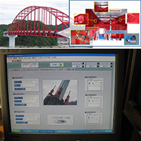
- Bridge Health Monitoring
- Health monitoring and diagnosis of bridge structures and other civil structures with sensing technologies and robotics
- ICT and Autonomous Control and Construction
- Hazardous area construction and monitoring with camera, gps, mems, and various electric devices such as unmanned construction system in the Unzen mt. area
- [Papers] Okumatsu et al: temperature effect for natural frequencies of a steel langer truss girder bridge, Proc. of 4th International Symposium on Life-Cycle Civil Engineering, (in CD-ROM) (2014.11).
Special Mention
- Infra monitoring system with ICT, environmental vibration measurement, autonomous control/construction
Associate ProfessorNISHIKAWA Takafumi
Field of Specialty
Structural Engineering
Research Topics
- Structural Integrity Monitoring of Infrastructure
- Measurement techniques for structural system identification have been developed, employing system identification theories such as the realization theory. Developed techniques allow measurement practices to be possible ‘on-line’ through ICT-aided computerized-operations ranging from data collection to showing results of analysis. The system demonstrates high identification accuracy and enhances its practicability through applications to several actual bridges.
- A Simple Pavement Diagnostic System Using Dynamic Responses of an Ordinary Vehicle
- A simple monitoring system, ‘vehicle intelligent monitoring system (VIMS)’, has been proposed for inspection of road surface conditions, objectively, promptly, and inexpensively. The system estimates the international roughness index by capturing the vehicle's dynamic response from its vertical acceleration. In this study, VIMS was introduced for road inspections in some countries.
- Image Processing Techniques for Detecting Structural Damage on Concrete and Asphalt Surfaces
- New robust automated image processing methods for detecting cracks in surface images of concrete and asphalt structures have been developed in this study. The focus of this study is the multiple sequential image filters that were generated by evolutionary computation with genetic programming. The developed method can be used for the accurate detection of cracks in surface images recorded under various conditions. Moreover, the widths of the detected cracks can be quantified on the basis of the spatial derivatives of the brightness patterns in sub-pixel resolution.
Associate ProfessorSUZUKI Seiji
Field of Specialty
Estuary Engineering / River Environmental Engineering
Research Topics
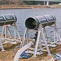
- Development of Water Quality Improvement Devices at Lakes
- Excessive growth in the population of blue–green algae is one of the most severe problems in lakes. To utilize the oxidation effect with ozone, new devices which improve water quality were developed.
- Study of Environmental Reclamation in Water area
- The ecosystem in aquatic regions has changed dramatically over the past century, because of human activities. A prediction of the trend for the ecosystem was developed utilizing field observations and numerical experiments.
Assistant ProfessorTANAKA Wataru
Field of Specialty
River Engineering / Biology
Research Topics
- Elucidation of the Relationship Between Topographical Origin and Biodiversity at the River Confluence
- In this study, we made a formation factor prediction such as merge angle and tributary flow rate of the riverbed topography at the river junction. The relationship between the biodiversity, riverbed topography, and biodiversity potential will be elucidated.
- Flood Control and Biological Evaluation of Traditional Flood Control Methods
- The traditional flood control methods that were adopted before the spread of modern engineering technology, persistently exerted flood control effects against external forces exceeding expectations and are anticipated to be effective against severe disasters that have increased rapidly in recent years. Therefore, we are evaluating these flood control effects and elucidating the impact on biodiversity.
ProfessorJIANG Yujing
Field of Specialty
Geo-environmental Engineering / Rock Engineering / Disaster Prevention Engineering
Research Topics

- Prediction and Measurement of Slope Disaster Induced by Torrential Rainfalls
- The slope stability prediction technique is established considering rainfall volume, duration, and ground characteristics. Moreover, the recently proposed remote monitoring system is being promoted for field utilization.
- Asset Management Technique for Road Tunnels
- The Asset Management system that includes GIS-based database, deterioration curve, priority ranking, reinforcement technology (e.g., FRP–PCM method), and LCC calculation has been developed for the effective maintenance and management of road tunnels.
- Methane Hydrate Development Techniques
- Effective development techniques are being established in compliance with environmental health standards because, during the construction process, there are occurrences of subsidence of seafloor, critical damage of casing due to the consolidation of the formations around the well, and collapse of the methane hydrate layer.
Special Mention
- Kyushu Construction Research Grant: “mechanism and evaluation technique of slope collapse caused by the torrential rainfall”
- Challenging Exploratory Research (JSPS): “developing rock slope hazard monitoring system with wireless network communication technology” (research representative).
ProfessorOMINE Kiyoshi
Field of Specialty
Geo-environmental Engineering
Research Topics

- Utilization of Disaster Wastes as Geo-materials
- A large amount of disaster waste was formed owing to the great east Japan earthquake. Compaction, CBR, and direct shear tests were conducted on the disaster waste obtained from several sites in the Tohoku region. An innovative approach that involves using compost containing halo/salt tolerance bacteria was tested to restore the saline soil.
- It was discovered that the disaster waste has a similar strength compared with the usual sandy soil. The disaster waste contains organic waste such as wood chips. It was considered that the organic waste will affect the strength of the disaster waste over a long term and discovered that the compost is useful for reducing the excessive salts from the soil.
- Geo-environmental Improvement Techniques Using Microorganisms for Sustainable Development
- Various geo-environmental issues have occurred at regional and global levels. Utilization of wastes and remediation of contaminated soils are examples of geo-environmental problems. When waste materials are utilized for geo-materials, it is necessary to adopt any suitable treatment technique for eliminating the harmful substances that may be present in the waste. From the viewpoint of reducing environmental load, a method with low cost and not involving the use of special chemicals is needed for sustainable development.
- A remediation method using aerobic or anaerobic fermentation is applied. The effect of composting with aerobic or anaerobic fermentation was discussed based on the test results. It is concluded that the anaerobic fermentation with organic matter, effective microorganism resources, and leaf mold are very effective for remedying the contaminated soil with hexavalent chromium.
Associate ProfessorSUGIMOTO Satoshi
Field of Specialty
Geo-environmental Engineering / Geo-disaster Engineering
Research Topics
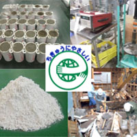
- Development of Low-alkaline Stabilizer with Recycled Materials
- In recent years, the amount of waste plasterboards continue to increase as a result of the reconstruction of houses or buildings in Japan. It is necessary that there are adequate recycled waste plasters to utilize as stabilizers. In this study, low-alkaline and harmless stabilizers were developed with recycled plaster, fly ash, bed ash, and burned sludge.
- Risk Assessment of Slope Failure due to Weathering or Human Alteration
- The potential risk of slope failure due to repeated heavy rainfall in Japan is ascribed to the cause of weathering progression or cutting slope and so on. In this study, the evaluation method is suggested via laboratory tests, numerical analysis, and in-situ tests using construction machines from the aspect of these causes.
Special Mention
- Both topics stated above have been carried out as joint research or funded research.
ProfessorSETO Shinta
Field of Specialty
Radio Hydrology
Research Topics
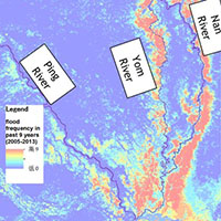
- Satellite Remote Sensing of Precipitation
- Virtually, on a global coverage, precipitation can be measured regardless of the land surface conditions through radars, microwave radiometers, and infrared radiometers on satellites. I have been working on the development of GSMaP, a gridded precipitation data (hourly and 0.1degree resolutions) with JAXA, and currently, I am working on the precipitation retrieval algorithm for the dual-frequency precipitation radar that will be in operation starting 2014.
- Water-related Disaster Prevention in Asia
- I have been working on collaboration studies with Thai researchers under the support of JICA. The purpose of the studies is to detect water-related disasters during their early stages and to mitigate the damages resulting from the disasters. Satellite remote sensing is an important tool in this project because ground-based measurements are not well organized in Thailand or some other Asian countries.
Special Mention
- The studies were supported mainly by JAXA (PMM) and JSPS (Kakenhi) for three years (2013–2015).
Associate ProfessorISHIBASHI Tomoya
Field of Specialty
Landscape Engineering / Urban History
Research Topics
- Historical Study on Urban Formation and Urban Policy Recommendations
- Proposals for future urban policies will be made by clarifying the transition of policies and the spatial transformation in each city. Specifically, we will analyze and consider primary materials such as master plan of the city, minutes of the city council, and various articles surrounding the city.
- Community-based Practical Research for Landscape Formation
- After the enforcement of the Landscape Act, conservation and utilization of landscape resources have been promoted in various regions of Japan. Therefore, we conducted community-based practical research for the selection of important cultural landscapes and the formation of wide-area landscapes for large-scale landscapes.
- [Papers] Journal of Japan Society of Civil Engineers, Ser. D1, Vol.71,No.1,pp.56–70(2015), Vol.70,No.1,pp.1–15(2014), etc.
Associate ProfessorYOSHIKAWA Sayaka
Field of Specialty
Hydrology / Remote Sensing / Land Use Change
Research Topics
")

- Assessment of Water Resources due to Climate Change and Land-Use Change
- With a particular focus on variations in land-use change and climate change, time-varying dependence of water requirements from various water supply sources are estimated during past and future periods. Future socioeconomic scenarios in Japan necessary to perform these analyses are being developed.
- Relationship Between Extreme Rainfall and Temperature Rise
- Application of Clausius-Clapeyron relationship (7%/degree) on the frequency change rate of extreme precipitation events are analyzed with different time scales in Japan past and future climates experiments for +1.5K, +2K, and +4K rise in the global mean surface air temperatures.
- Deforestation Dynamics and the Factors of Change in Amazon
- Legal Amazon has experienced dramatic deforestation since the 1970s. Effectiveness of Brazil government intervention is subject to fluctuate depending on the state of the government. Identify changes in agro-pastoral development and relationship to each government period and land-use change are necessary.
Special Mention
- JSPS KAKENHI Grant Number JP20H04427, JP17K12847
- Environment Research and Technology Development Fund (JPMEERF20S11801) of the Environmental Restoration and Conservation Agency of Japan
home![]() English: Laboratories
English: Laboratories


TEL : 095-819-2626 / FAX : 095-819-2627
 :
:
